1 Introduction
The negative consequences of urban traffic disruption are becoming increasingly serious, not only threatening urban mobility, but also seriously affecting economic activities and the daily lives of residents. Previous studies have shown that traffic disruptions can affect traffic flows, increase commuting times and cause various social and environmental problems (Currie & Muir, 2017; Gasparinatou et al., 2023; Marra & Corman, 2023; Yap & Cats, 2022). In the existing literature on traffic disruptions, extensive research has been carried out on the impact of road accidents (Liu et al., 2021; Zhu & Levinson, 2010), but studies focus on unplanned traffic disruptions (such as road accidents and temporary road closures), which are even more serious than planned disruptions (Marra & Corman, 2023).
Traffic disruptions show clear temporal and spatial variations, influenced by peak travel times and seasonal changes, requiring adaptive traffic management strategies. This temporal variation, coupled with geographical variation, with densely populated areas and major road networks experiencing more severe congestion, emphasises the critical need for specific spatial analysis to manage these hotspots effectively. From an economic perspective, bottlenecks have far-reaching effects, affecting not only direct traffic flows, but also the local economy as a whole. This dynamic emphasises the importance of understanding the temporal and geographical trends in traffic disruption and how people adapt to it to design effective interventions, particularly in the West Midlands.
This study examined traffic disruptions in the West Midlands region for 2023, uncovering both spatial and temporal differences in unplanned traffic events across various areas. By analysing the general pattern of incidents, and examining a series of incidents as a case study, this study endeavours to offer novel insights into the spatial and temporal dynamics of traffic disruptions and their broader socio-economic impacts. The findings are intended to inform the development of more resilient and responsive urban transportation systems.
2 Data and Methods
2.1 Data and Pre-processing
This study used dataset provided by Transport for the West Midlands, which contains vehicle speed data recorded every five minutes through 2023, as well as detailed incident records on incident type, severity and location. Data preprocessing included converting time stamps to UK local time (BST), extracting incidents as ‘unplanned failures’ and FRC codes to accurately classify roads. I also created a GeoDataFrame using the H3 package to assemble and analyse the hexagonal grid into which the data was merged.
2.2 Temporal and Spatial Characteristics
Statistical and geospatial methods were used to investigate the temporal patterns and spatial distribution of unplanned traffic disruption. Time-series analysis was used to assess changes in traffic flows up to 2023. Geospatial analysis, including heat maps and cluster analysis, identified high-severity locations and visualised the geographical distribution of unplanned disruptions in the West Midlands.
2.3 Case Study
This study also conducted a case study focused on a series of unplanned disruptions on the highway by examining a 5-kilometre radius buffer area. The analysis included changes in average speed, delay time and traffic congestion dynamics to observe adaptive behaviour. In addition, in order to investigate the economic perspective, economic impacts were examined by calculating the value of costs (DfT, 2015), to allow for a direct assessment of the economic impact of disruption.
3 Results
3.1 Temporal and Spatial Pattern
During 2023, unplanned traffic disruption in the West Midlands shows significant temporal and spatial patterns. As shown in Figure 1, the temporal pattern shows monthly variations in the frequency of traffic disruption, with the 7-day moving average (red line) showing weekly fluctuations. The number of incidents shows a high degree of fluctuation in spring (February to May), with a noticeable minimum in March. In the summer months (June to September) there is a downward trend, with a gradual return to average levels between October and December. Weekday accidents (×) are typically more frequent than weekend accidents (△), which may be related to the higher volume of traffic on weekdays. Interestingly, although incidents are less frequent on weekends, they tend to be more serious. Please note the severity metric is directly from INRIX dataset, and this may be different from metrics calculated from speed difference.

Figure 2 shows a spatial visualisation of unplanned disruptions in the West Midlands, with subplots (a) and (b) showing the frequency of serious incidents and the number of incidents respectively. Subplot (a) indicate that serious incidents are predominantly occurring in well-developed urban areas such as Birmingham city centre and Coventry. There is also a cluster of serious incidents on major transport corridors such as the M5, M6 and A4123. The second plot (b) shows that the distribution of accidents is uneven across the region, with accidents concentrated in certain places along motorways, particularly around junctions 9 and 10 of the M6, which account for 15% of all regional accidents. These results show that motorways are a potential intervention point for traffic management.
In the next section, it will explore these trends in more detail through a case study of a series of accidents on the M6 motorway on 31 January 2023.


Figure 2: Spatial visualisation of incidents
3.2 Case Study: 31 January, 2023 Incident
On 31 January 2023, there was a series of traffic disruptions on the M6 motorway, as detailed in Table 1. This section will analyse the impact of the incident on average travel speed, delay times and economic costs.
| Time | Event | Location | Details |
|---|---|---|---|
| 13:03 | Initial traffic slow due to construction work at J10 | M6 Northbound J10 | Slow traffic, congestion starts due to construction |
| 13:12 | Slow traffic from J7 to J9. Lanes affected by closures and roadworks | M6 Northbound between J7 and J9 | Continuous traffic impact due to lane closures and roadworks |
| 13:20 | RTC near J9 (Confirm needed) | Black Country, Walsall | Main accident event that initiated traffic disruptions |
| 15:29 | Incident closure for RTC near J9 | Black Country, Walsall | Closure of incident logged in RTC system |
| 18:46 | Slow traffic ended | M6 Northbound between J7 and J9 |
The analysis of the average speed on 31 January 2023, which compares the actual speed on that date (red line) with the average speed collected on Tuesdays (blue dashed line), as shown in Figure 3. The blue-shaded areas represent the 5th to 95th and 25th to 75th percentiles of the historical speed on Tuesdays. A significant reduction in speeds can be observed during the morning and evening peak periods, with speeds on this day of the week between 1 pm and 7 pm significantly below the historical average. This pattern indicates a period of heavy congestion due to traffic accidents, indicating the severe impact of traffic accidents on traffic flow.
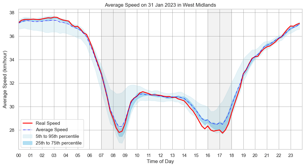
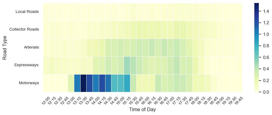
Figure 4 details the delay time per kilometre by road type throughout the day in the case study area. Motorways (red line) experienced the longest and highest delays, particularly during the afternoon peak, due to the incident near junction 9. Although expressways and arterials were also affected, their delays were approximately one-third of those on the M6 motorway. Following the resolution of the incident, highway delays sharply reduced to levels comparable to other roads, but it took about three hours post-incident for delays to return to normal levels. This pattern reveals the prolonged and complex impact of accidents on traffic flow and highlights the importance of network resilience.

To complement the findings in Figure 4, Figure 5 presents a geographical animation of the spatial variation in traffic delays caused by the incidents. It demonstrates congestion mainly occurring between 13:00 and 15:30, corroborating the peak highway delays identified in Figure 4. Beyond the M6 itself, delays spread to adjacent roads, notably the northbound routes through Walsall (Pleck Road and A34) and the exit from M6 to A454 (Junction 10), likely indicating commuter behaviour shifts as drivers sought alternative routes to circumvent congestion.
To assess the economic impact of events, Figure 6 quantifies the cost of additional travel time for a commuter based on road type. During the incident, the highest costs were incurred on highways, which peaked between 1 pm and 3 pm. When congestion was at its highest, commuters paid an extra £1.50 for every kilometre travelled. Interestingly, a delay of about 1 hour was observed in the process of the impact from the affected road to the adjacent road, suggesting a delayed propagation of traffic pressure.
4 Discussion and Conclusion
This study analysed unplanned traffic disruption in the West Midlands during 2023, highlighting the temporal and spatial characteristics of road accidents and the economic impact. The findings of the study highlighted that areas such as Birmingham and Walsall were experiencing the worst disruption; In particular, junctions 9 and 10 of the M6 motorway are accident hotspots, indicating the need for targeted interventions in these critical areas. This is in line with findings that motorways are prone to serious collisions due to their design and high traffic volumes (Stiles et al., 2023). Therefore, it is recommended that traffic infrastructure and signalling systems should be improved to reduce accidents (Hsiao et al., 2018).
While previous research has generally covered the general characteristics of road accidents, this study specifically examines an unplanned disruption, which often causes severe congestion (Liu et al., 2021; Zhu & Levinson, 2010). The detailed analysis of incidents on the M6 on the 31 January 2023 showed that unplanned disruptions not only significantly increase delay times on the directly affected roads, but also have a cascading effect, spreading to neighbouring roads. The finding also demonstrated that commuters may choose alternative routes to avoid the usual faster routes (motorways), inadvertently causing congestion on these alternative routes. The economic analysis identified the significant cost incurred by commuters, highlighting the significant economic impact of traffic disruption.
However, the study has limitations. First, although it addresses the spatial and temporal aspects of traffic disruption, it does not address the role of travel behaviour during disruption and the effectiveness of traffic management strategies. Second, analysis based on single-day or region-specific events may not be generalisable. Third, the economic analysis identifies the direct costs incurred by commuters but also emphasises the need for a deeper understanding of indirect costs.
In conclusion, this research emphasises the urgent need for resilient urban transport systems capable of adapting to and mitigating the effects of traffic disruptions. Future studies should continue to investigate the behavioural determinants of road disruptions, particularly through the application of behavioural theories and models, to better understand how people change their travel behaviour in response to traffic disruptions.
6 Reference
Currie, G., & Muir, C. (2017). Understanding passenger perceptions and behaviors during unplanned rail disruptions. Transportation Research Procedia, 25, 4392–4402. https://doi.org/10.1016/j.trpro.2017.05.322
DfT. (2015). Values of travel time savings and reliability: final reports. https://www.gov.uk/government/publications/values-of-travel-time-savings-and-reliability-final-reports
Gasparinatou, C., Mantouka, E., Vlahogianni, E. I., Masegosa, A. D., & Serrano, L. (2023). Travel behavior shifts under extreme system-level disruptions. Transportation Research Procedia, 72, 1420–1426. https://doi.org/10.1016/j.trpro.2023.11.606
Hsiao, H., Chang, J., & Simeonov, P. (2018). Preventing Emergency Vehicle Crashes: Status and Challenges of Human Factors Issues. Human Factors, 60(7), 1048–1072. https://doi.org/10.1177/0018720818786132
Liu, T., Ma, Z., & Koutsopoulos, H. N. (2021). Unplanned Disruption Analysis in Urban Railway Systems Using Smart Card Data. Urban Rail Transit, 7(3), 177–190. https://doi.org/10.1007/s40864-021-00150-x
Marra, A. D., & Corman, F. (2023). How different network disturbances affect route choice of public transport passengers. A descriptive study based on tracking. Expert Systems with Applications, 213, 119083. https://doi.org/10.1016/j.eswa.2022.119083
Stiles, J., Kar, A., Lee, J., & Miller, H. J. (2023). Lower Volumes, Higher Speeds: Changes to Crash Type, Timing, and Severity on Urban Roads from COVID-19 Stay-at-Home Policies. Transportation Research Record, 2677(4), 15–27. https://doi.org/10.1177/03611981211044454
Yap, M., & Cats, O. (2022). Analysis and prediction of ridership impacts during planned public transport disruptions. Journal of Public Transportation, 24, 100036. https://doi.org/10.1016/j.jpubtr.2022.100036
Zhu, S., & Levinson, D. M. (2010, January 14). Transportation research board 89th annual meeting. https://trid.trb.org/View/910420
